Data offer present condition of the retrieve target country
3.2 Patent Map
Patent Map is analysis result that use MicroPatent company's patent analysis Tool “Aureka”, and there is meaning that whole technology takes a view of patent's distribution chart by (Keyword base) at a look. Height means high density extent (Number) of literature in contour line image and closeness of line displ
1. Location-Based Service Background
1.1. Definition of Location-Based Service
Location-Based services refer to general class of computer program-level services used to include specific controls for location and time data as control features in computer programs. Location-Based services utilize location information to improve business productivity as well as adding value to a comfortable life.
개요
중력탐사 자료처리실습의 과정은 측정된 data를 바탕으로 위도보정, 고도보정, 지형보정을 시행하여 부게이상을 구한다(엑셀 프로그램 사용). 계산된 부게이상 data를 Surfer프로그램을 통하여 contour map으로 나타낸다. 중력이상이 나타나는 지점에 측선을 긋고 측선위의 data를 그래프로 나타내어 Ha
Location-Based Service Market Overview
LBS refer to class of computer program-level services used to include specific controls for location and time data as control features
Device Manufacturers
Samsung, Apple
Content Provider
3rd parties (restaurants, etc.)
Location Provider
Telecommunication companies (KT)
LBS Provider
Groupon, Foursquare, etc.
An active service requires the
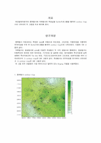
개요
화산칼데라분지의 중력탐사와 자력탐사의 측정값을 Surfer프로그램을 통하여 contour map 으로 나타내어 두 그림을 비교 해석해 본다.
연구과정
중력탐사 자료처리는 측정된 data를 바탕으로 위도보정, 고도보정, 지형보정을 시행하여 부게이상을 구한 후 Surfer프로그램을 통하여 contour map으