spatial composition. In short, we can say that people’s behavior is important factor when we build the house.
For this reason, we used psychology & behavior test “DISC” made by William Mouston Marston Ph.D. The reason why we choose DISC test is that DISC test divides people into 4 types based on behavior pattern and explains appropriate environment for each type of behavior pattern.
In b
Time flies like an arrow; fruit flies like a banana. Oettinger (1966)
컴퓨터가 자연적인 언어(natural language)를 처리하도록 하는 데에 있어서의 어려움에 대한 초기의 연구에서, Anthony Oettinger는 우리가 예상되는 구조(expected structure)에 기반하여 어떻게 문장을 번역하는지, 그리고 우리가 번역하며 오류를 범했을 때,
*’Nano’ means….
Nanometer: one billionth of a meter
Nano-: prefix comes from the Greek word for ‘dwarf’
Chemical, physical, and biological properties that differ from those of their larger, or bulk counterparts
Nanotechnology: The National Nanotechnology Initiative(NNI)-> the science of materials and phenomena in the range of 1 to 100nm in diameter
*Features of ‘nanoparticles
spatial region)과 주파수 영역(frequency region)등에 각각의 application에 알맞은 방법으로 삽입된다. 일반적으로 RST 변환에 강한 LPM(Log-Polar Mapping)이나 FMT(Fourier-Melling Transform)이나 JPEG(Joint Photography Expert Group) 알고리즘의 기준이 되는 DCT(Discrete Cosine Transform)영역이나 DFT,WDT등의 주파수 영역에서의 새로운 알고리
features and services is provided for an assumed capacity of visitors. It is important in planning the services businesses to realize that they gain from clustering. Food services, lodging, and supplementary services must be grouped together and within reasonable time and distance reach for the visitor.
7)The institutional environment
The institutional elements need to be considered i
Ⅰ. 서론
교육 컨텐츠의 제작에 있어서도 좋은 품질을 유지하기 위해서는 제작비용이 소요될 것이고, 이를 조달하는 방법이 필요하게 될 것이다. 결국 유료화된 교육 컨텐츠 서비스 사이트가 경쟁력을 가지게 될 것이며, 제작비용이나 기술의 차이가 교육 컨텐츠의 서비스 품질 차이로 나타나게 될 것
Ⅰ. 서론
조직의 노하우가 축적된 지식정보의 원활한 공유 및 문서관리 업무자동화 등을 돕기 위한 기업전산화 작업이 EDMS, KMS, ERP, EP, 그룹웨어 등의 도입을 통하여 빠른 속도로 진행되고 있다. 그러나 디지털화된 중요 정보들이 쉽게 외부로 유출되는 심각한 부작용이 발생하였고 막대한 경제적인
Ⅰ. 서론
GIS시장은 두 가지 방향으로 나아가고 있는데, 하나는 데스크탑 환경에서 보다 손쉽게 사용자가 기능을 습득하고 사용할 수 있도록 소프트웨어 및 데이터를 제공하는 것이며, 다른 하나는 전문적인 업무나 문제를 해결하기 위해 각 특정 환경이나 조건에 맞는 GIS 시스템을 구현하는 것이다.
Feature - based Systems
얼굴의 눈, 코, 입과 같은 해부학적 특징들을 이용하는 방법이다. 이들 특징들은 고정된 상대위치를 가지며, 얼굴 포즈에 따른 기하학적 관계가거의 변함이 없다. 여기에는 특징 형판(feature template)과의 이미지 상관도(image correlation)를 이용하는 방법이 있는데,
<중략>
CheckDetect
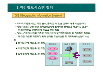
1.지리정보시스템 정의
GIS (Geographic Information System)
- 지리적 자료를 수집, 저장, 분석, 출력 할 수 있는 컴퓨터 응용 시스템이다.
- 정보시스템 : 모든 인간 의사결정과정에 발생하는 문제점을 해결하고 효율적인 접근방안을 모색하는데 도움을 주는 작업
- 정보시스템의 원리를 기초로 하여 지표의 공